Here are some cool maps I’ve made. They were all produced using open-source tools (namely R and Inkscape).
Tropical lagoon nutrients

Long-term proxies for nitrogen enrichment (a) and instantaneous water column samples (b) are positively correlated (c) in lagoons of Moorea, French Polynesia. Lagoon nutrients are generally higher near shore (d) but vary around the island, with evidence of nutrient enrichment at some offshore sites such as reef passes (e).
John et al. 2025 Limnology and Oceanography
North American tundras

Arctic and alpine tundra landscapes are found at high latitudes and elevations of North America, with decreasing density and contiguity toward the south. These seasonal environments are characterized by harsh winters and vibrant summers.
John 2025 in Global Biome Conservation and Global Warming: Impacts on Ecology and Biodiversity
Bioclimatic forecasts for North American Bovidae
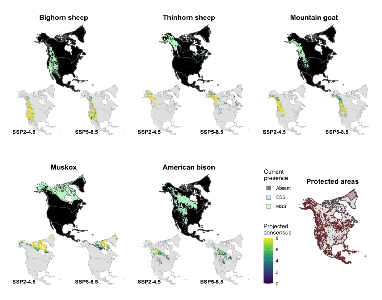
Bovids - members of the cattle family - are distributed across open and rugged landscapes of North America. Here we report on end-of-century projections from a series of machine learning species distribution models using data from museum collections, universities, and community science efforts.
John and Post 2022 Ecology and Evolution
Caribou migration routes threatened by proposed roads

Caribou migratory routes such as those of the Western Arctic herd (Alaska, USA) and Kangerlussuaq-Sisimiut herd (Qeqqata, Greenland) could be impacted by the development of roads (black lines), which are proposed to overlap with caribou’s seasonal ranges (white winter hatched and summer cross-hatched polygons) or migratory corridors.
John 2025 in Global Biome Conservation and Global Warming: Impacts on Ecology and Biodiversity
Circumarctic distribution of dwarf birch and grey willow

A fusion of multiple data sources to visualize the occurrence records of Betula nana and Salix glauca.
Study site in low-arctic Greenland

Map of the study site at the calving grounds of the Kangerlussuaq-Sisimiut caribou herd, a population whose distribution is bounded by the Davis Strait, Nordre Isortoq, Sukkertoppen Ice Cap, and Greenland’s Inland Ice. Kangerlussuaq and Sisimiut indicated by K and S, respectively.
Eikelenboom et. al 2021 Food Webs
Study site in the eastern Sierra

Map of the study area in the Sierra Nevada Mountains of California. We used a network of 135 time-lapse cameras (blue dots, A) distributed across the range of endangered Sierra Nevada Bighorn Sheep (B) to track patterns of snowmelt and plant growth relevant to their spring migration from the Owens Valley to the High Sierra (C).